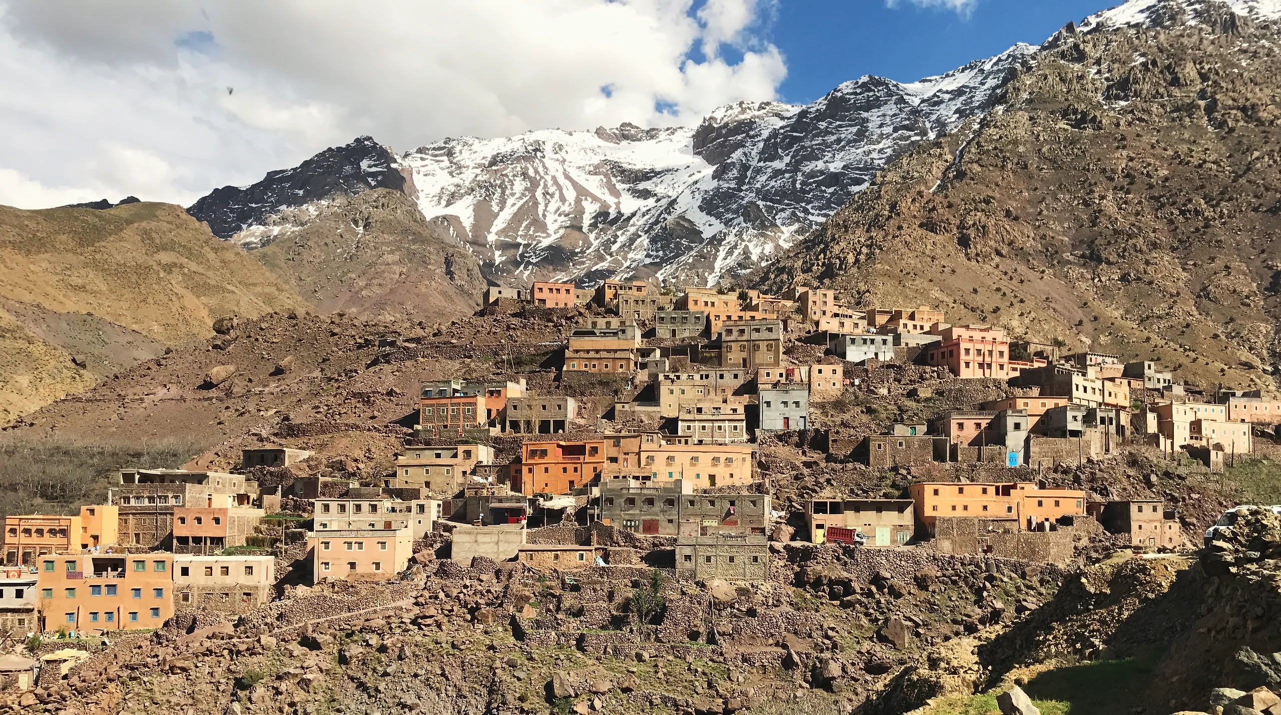
Flat-roofed houses of a village in the Imlil valley stacked up a hillside below snow-covered High Atlas peaks

Day trips from Marrakech

Atlas Mountains Day Trips from Marrakech

Seven trips into the High Atlas and its foothills, from a stroll through the Asni market to the climb to the Toubkal refuge, with distances, costs and when you need a guide.

A village in the Imlil valley, on the way to Jebel Toubkal. Photograph: Erokhin, CC BY-SA 4.0

Imlil
64 km, ~90 min
Setti Fatma
~65 km
Guide
Required in Toubkal NP
Tours from
200 MAD

Why the Atlas Mountains Make the Perfect Day Trip

The High Atlas rises from the Haouz Plain south of Marrakech, from about 450 m to over 4,000 m at Jebel Toubkal. You can breakfast in a Marrakech riad, spend the day at a waterfall or drinking tea in an Amazigh home at 2,000 m, and be back for dinner.

Below are seven trips, from the easiest (Agafay, no walking needed) to the hardest (the Toubkal refuge at 3,207 m), each with distances, travel times, costs, difficulty and whether you need a guide.

Seven Atlas Day Trips

For families: Ourika, Agafay or the Asni market. For walkers: Imlil, Azzaden or the Toubkal refuge. In winter: Oukaimeden.

Imlil Valley & Armed Village Walk

Imlil sits at the foot of Jebel Toubkal, North Africa's highest peak, and the walk from Imlil to Armed takes about 90 minutes on a well-worn dirt path, through terraced fields and walnut groves and over the river on a simple footbridge. Armed is a stone-and-mud village where several homes welcome visitors for tea. The round trip takes 3–4 hours at a comfortable pace with stops.

  • Walk through walnut and cherry orchards to the village of Armed
  • Mint tea with a family in a traditional Amazigh house
  • Toubkal (4,167 m) above the valley on clear days
Distance
64 km from Marrakech
Travel time
90 minutes each way
Difficulty
Easy to moderate
Elevation
1,740 m (Imlil)
Best season
Year-round (snow possible Dec–Feb)
Guided
From 800 MAD (private, 2–4 people)
Independent
From 200 MAD to reach Imlil (grand taxi + lunch); a guide is extra
Getting there
Grand taxis leave from Bab er-Rob in Marrakech for from 25 MAD per person (shared) or from 250 MAD for the whole taxi. The road is paved all the way to Imlil. Or book a private driver through your accommodation.
Guide
Imlil is in Toubkal National Park, where foreign hikers must walk with a licensed mountain guide. Guides charge from 400 MAD per day; the Bureau des Guides in Imlil can arrange one, and a guide can also take you to quieter hamlets and arrange home visits.
Bring
Walking shoes with grip · Sun hat and sunscreen · 1.5 L of water · Cash in small notes for tea and tips · Light layers (10–15° cooler than Marrakech)
Ourika Valley & Setti Fatma Waterfalls

The road follows the Ourika River past green fields, Amazigh villages and fruit stalls to Setti Fatma, where a chain of seven waterfalls drops through a narrow gorge. Most visitors climb to the first waterfall (30 minutes, a moderate scramble) and the second (another 20 minutes, steeper). Riverside restaurants at the bottom serve tagine. On Mondays the market at Tnine Ourika sells pottery, spices and livestock.

  • The first two of the seven waterfalls at Setti Fatma
  • Tagine at a riverside restaurant
  • The Monday market at Tnine Ourika
Distance
Valley from 35 km; Setti Fatma about 65 km
Travel time
Over an hour each way to Setti Fatma
Difficulty
Easy (valley) / moderate (waterfalls)
Elevation
1,000 m (valley floor) to 1,500 m (upper falls)
Best season
March to November
Guided
From 600 MAD (private, 2–4 people)
Independent
From 150 MAD (shared taxi + lunch)
Getting there
Grand taxis leave from Bab er-Rob, from 20 MAD shared. The road is paved. After heavy rain, especially in November and March, check conditions: flash floods occasionally close the final stretch.
Guide
The valley drive is easy on your own. At Setti Fatma, hire a local guide for the waterfalls: the path is unmarked and they know which rocks are stable.
Bring
Water shoes or sandals with grip · A swimsuit for the pools · A waterproof phone pouch · 2 L of water · Cash for the guide and lunch

Oukaimeden: Ski Station & Rock Carvings

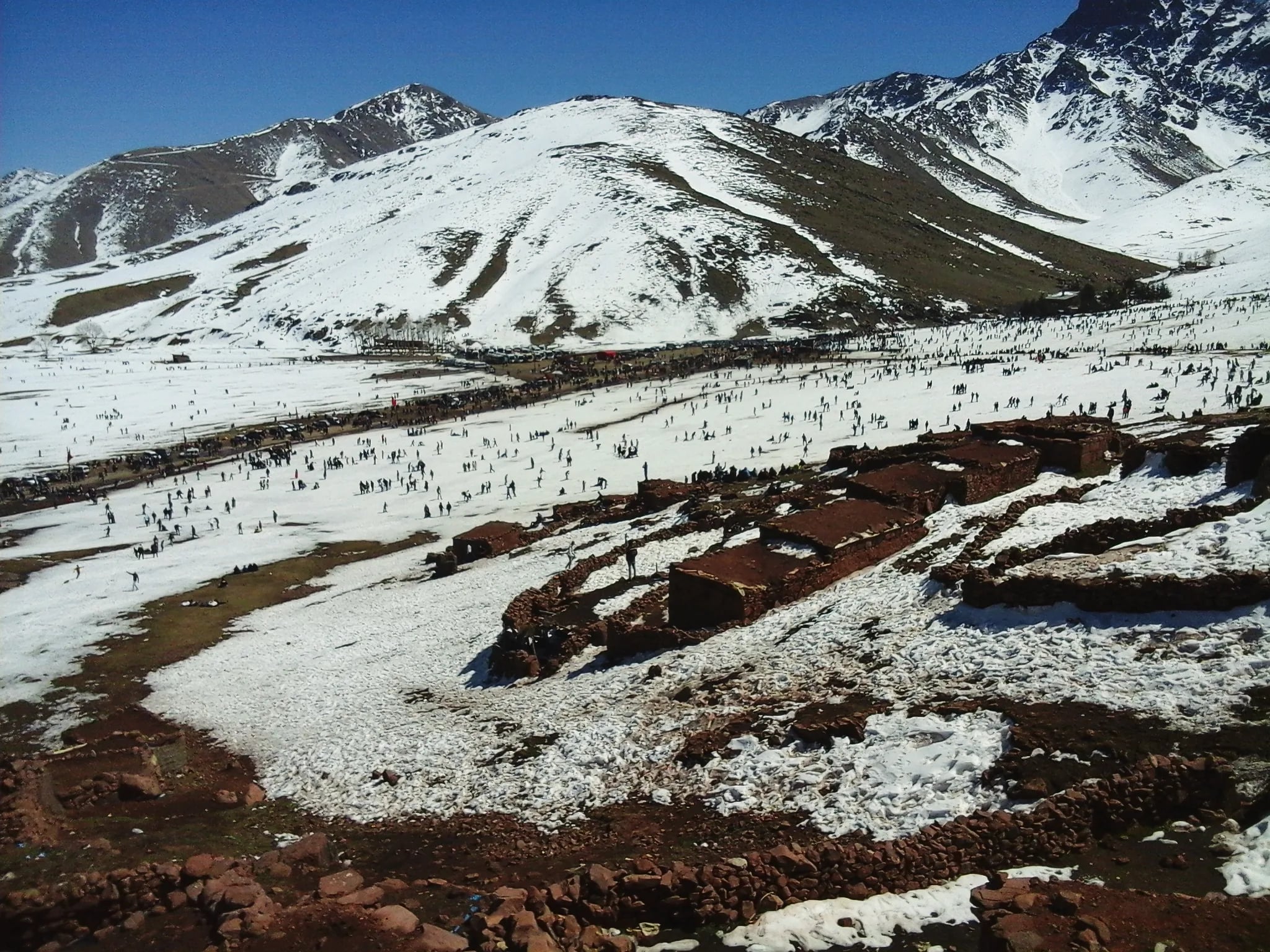
Oukaimeden sits on a high plateau at 2,600 m and is Morocco's main ski station from December to March, though snow is not guaranteed every year. Outside the ski season it is a walking destination with summer wildflowers and cool temperatures. Across the plateau are Bronze Age rock engravings of weapons, animals and sun symbols; a local guide can show you the ones most visitors walk past.

  • Skiing or sledging on the plateau in a snowy winter
  • Bronze Age rock engravings scattered around the plateau
  • Summer walks among wildflowers in cool air
Distance
75 km from Marrakech
Travel time
Up to 2 hours each way
Difficulty
Easy (village and carvings) / moderate (skiing)
Elevation
2,600 m (station)
Best season
December to March (ski) / June to September (hiking)
Guided
From 900 MAD (private, 2–4 people)
Independent
From 300 MAD (taxi, before ski costs)
Getting there
No regular public transport. A grand taxi from Marrakech costs from 400 MAD for the whole car. The road is paved but steep, with switchbacks; in winter chains may be needed near the top. A private excursion is the most practical option.
Guide
A guide helps you find the rock carvings (from 200 MAD). Skiing is self-directed, with equipment for hire at the station.
Bring
Winter: warm jacket, gloves, snow boots · Summer: hiking boots, sunscreen, hat, windbreaker · Binoculars for the carvings · 2 L of water · Snacks (little food at the station)
Hundreds of people out on the snow of the Oukaimeden plateau below white mountains, with stone huts in the foreground
A winter day on the snow at Oukaimeden. Photograph: Abdelhak-fekirrin, CC BY-SA 4.0

Toubkal Base Camp (Refuge) Trek

From Imlil the trail climbs steadily up the Mizane Valley, past the shrine of Sidi Chamharouch, a pilgrimage site for Moroccans, to the Toubkal Refuge at 3,207 m. The climb takes 4–6 hours and the descent 3–4, so most people sleep at the refuge, and the summit itself needs that overnight. As a day trip it means 8–10 hours on foot plus three hours on the road, for fit walkers only. You will feel the altitude above 2,800 m.

  • The base of North Africa's highest mountain
  • About 1,450 m of climbing up the Mizane Valley
  • The shrine of Sidi Chamharouch on the way
  • Barbary ground squirrels on the scree
Distance
64 km to Imlil, then about 10 km on foot each way
Travel time
90 minutes' drive, then 4–6 hours up and 3–4 down
Difficulty
Challenging
Elevation
1,740 m (Imlil) to 3,207 m (Refuge du Toubkal)
Best season
April to June, September to October
Guided
From 1,200 MAD per person (guide + mule)
Independent
Not possible: a licensed guide is required
Getting there
As for Imlil (grand taxi or private driver). The trail starts in Imlil village, where the Bureau des Guides arranges licensed guides.
Guide
A licensed mountain guide is required for foreign hikers in Toubkal National Park. Guides set the pace, watch for altitude sickness and arrange a mule for your pack. Book at the Bureau des Guides in Imlil or through your Marrakech accommodation.
Bring
Hiking boots with ankle support · Trekking poles · 3 L of water · High-energy snacks (nuts, dates, chocolate) · Rain jacket and a warm fleece (the refuge is cold even in summer) · A headlamp

Asni Saturday Market & Moulay Brahim Gorge

Asni is a small town on the road from Marrakech to Imlil, and every Saturday it holds a working market where mountain families buy and sell sheep, goats and donkeys, seasonal produce, spices, household goods and second-hand clothes. Combine it with the Moulay Brahim gorge, a narrow canyon with a river and a shrine on the hillside above the road. The whole trip takes half a day and needs no hiking.

  • The weekly market, where mountain villagers trade livestock, produce and tools
  • The Moulay Brahim gorge and its hillside shrine
  • Walnuts, almonds and mountain honey from the farmers
Distance
47 km from Marrakech
Travel time
60 minutes each way
Difficulty
Easy
Elevation
1,150 m (Asni)
Best season
Year-round (market on Saturdays)
Guided
From 500 MAD (private, 2–4 people)
Independent
From 100 MAD (grand taxi + market spending)
Getting there
Grand taxis from Bab er-Rob, from 15 MAD shared. The road is paved and fast. Asni is the turn-off for Imlil, so you can combine both in one day.
Guide
The easiest Atlas trip to do on your own; no guide needed. A driver from Marrakech can combine the market with Imlil for a full day.
Bring
Comfortable walking shoes · Small notes (5, 10, 20 MAD) · A bag for your purchases · Hat and sunscreen

Azzaden Valley & Tizi Oussem Village

The route leaves Imlil, climbs over the Tizi Mzik pass at about 2,480 m and drops into the parallel Azzaden Valley to the village of Tizi Oussem. The landscape changes from terraced orchards to open grassland to juniper woods. Tizi Oussem has a few gîtes that serve lunch. Imlil to Tizi Oussem is 5–6 hours on foot, so a return the same day is a very long day; many walkers stay the night in a gîte.

  • The Tizi Mzik pass (about 2,480 m), with views over the Imlil and Azzaden valleys
  • The quieter Azzaden Valley
  • Lunch in Tizi Oussem, a village with gîtes
  • Juniper woods and small waterfalls fed by snowmelt
Distance
64 km to Imlil, then on foot
Travel time
90 minutes' drive, then 5–6 hours on foot to Tizi Oussem
Difficulty
Moderate to challenging
Elevation
1,740 m (Imlil) to 1,850 m (Tizi Oussem), over a pass of about 2,480 m
Best season
March to November
Guided
From 900 MAD (private, 2–4 people with guide)
Independent
From 350 MAD (transport + guide)
Getting there
Drive to Imlil (as for the Imlil trip). The walk starts in the village.
Guide
A licensed guide is required (the route is in Toubkal National Park), and you would want one anyway: the trail over Tizi Mzik is unsigned and forks several times. Expect to pay from 500 MAD for a guide.
Bring
Hiking boots · Trekking poles for the descent · 2.5 L of water · Lunch or snacks for the pass · A warm layer (the pass is windy even in summer)

Agafay Desert & Atlas Foothills Combo

Agafay is not a sand desert but a stony plateau between Marrakech and the Atlas foothills: flat, grey-white ground with almost no vegetation, and the High Atlas along the southern horizon. Several camps here offer camel rides, quad biking and meals in tents. It works as a half-day trip or combined with a drive into the lower Atlas villages, and it is the least strenuous trip on this list.

  • A camel or quad-bike ride across the stony Agafay desert
  • The wall of the High Atlas rising from the plain
  • Tea and oven-baked bread with a family in the foothills
Distance
40 km from Marrakech
Travel time
45 minutes each way
Difficulty
Easy
Elevation
500–700 m
Best season
Year-round
Guided
From 700 MAD (private, 2–4 people)
Independent
From 250 MAD (taxi + camel ride)
Getting there
Taxi or private driver from Marrakech. The road is paved for the first 30 km, then tracks lead to the camps and viewpoints. Most camps arrange their own transfers.
Guide
The camps handle everything if you book through them. You can visit the plateau on your own, but there is little to do without an organised activity.
Bring
Sunglasses and sunscreen · A light scarf for wind and dust · Closed-toe shoes for quad bikes · Cash for tips

Getting to the Atlas from Marrakech

Grand taxi, shared
From 15–25 MAD per personFrom Bab er-Rob or Bab Ghmat to Asni, Ourika and Imlil. The taxi leaves when all six seats are filled; cheap but no timetable.
Grand taxi, private
From 250–500 MAD for the carBuy all six seats and leave at once. Agree the price before departure, and agree a waiting or pickup time.
Private driver or tour
From 600–1,500 MAD per dayBook through your riad, hotel or a Marrakech agency. Air-conditioned car, set route, the driver waits at each stop.
Rental car
From 300 MAD per dayThe roads to Imlil and Ourika are paved, with tight switchbacks. Not for you if local driving habits make you nervous.

Atlas Day Trips by Season

Spring (March–May)
Waterfalls and wildflowersWildflowers in the valleys, snowmelt in the waterfalls, 15–22° at mid-altitude; snow lingers on passes above 3,000 m. March can bring heavy rain, so check the Ourika road.
Summer (June–August)
High walks, early startsHot below 1,500 m (30–35°), pleasant above 2,000 m (18–25°), clear skies most days. Good for the Toubkal refuge, Oukaimeden and Azzaden; start before 8 am on lower trails.
Autumn (September–November)
Stable, clear weatherDry and settled, 12–20° at mid-altitude, with the walnut harvest in the Imlil valley and long views. Late November brings the first cold snaps and sometimes early snow.
Winter (December–February)
Snow above 2,500 mOukaimeden runs as a ski station; valley floors stay open but cold (5–10°), days are short and passes may close. The Toubkal refuge and high passes are for experienced winter walkers with proper gear.

What to Pack

  1. Hiking boots or sturdy walking shoes

    Ankle support matters on rocky ground.
  2. Sunscreen SPF 50+

    UV is intense at altitude; reapply every 2 hours.
  3. A wide-brim hat or cap

    Even on cloudy days.
  4. Layers

    10–15° cooler than Marrakech, and windy on the passes.
  5. Rain jacket or windbreaker

    Mountain weather changes fast, especially in spring and autumn.
  6. Water, 2–3 litres

    No shops on the trails, and tap water is not safe to drink.
  7. Snacks

    Dates, nuts and chocolate.
  8. Cash in small notes

    For tea, tips and lunch; there are few or no cash machines in the villages.
  9. A basic first-aid kit

    Plasters, antiseptic, painkillers, anti-diarrhoeal tablets.
  10. Trekking poles

    They spare your knees on the descents.

Practical Tips for Atlas Day Trips

  1. Money and tipping

    Bring cash. Tip guides from 50–100 MAD per person for a day. Tea offered in a family home is free, but leaving something is appreciated.
  2. Photographs

    Ask before photographing villagers, especially women. Landscapes are fine. The early morning light, before 9 am, is warmest.
  3. Altitude

    Altitude sickness is unlikely below 3,000 m but possible on the Toubkal refuge trek (3,207 m): headache, nausea and fatigue. Go down if symptoms worsen, drink plenty and don't rush. Phone signal is patchy above 2,000 m. In an emergency call 19 in towns, 177 (Royal Gendarmerie) outside towns, 15 for an ambulance, or 112 from a mobile.
  4. Footwear

    Sandals do for Agafay and the Asni market. Every other trip needs closed shoes with grip, and the Toubkal refuge and Azzaden need proper boots with ankle support.
  5. The temperature gap

    Marrakech can be 35° while Imlil is 20° and the Toubkal Refuge 8°: the air cools about 6.5° for every 1,000 m you climb. Carry a fleece or warm jacket, even in summer.
  6. Village life

    People live and work in these villages all year. Stay on the paths, don't enter homes uninvited, and cover shoulders and knees. If invited for tea, accept. "Azul" (hello) in Amazigh is a good start.

Suggested Day Trip Combos

For a stay of several days in Marrakech.

  1. Two days: Ourika, then Imlil

    Start with the easier Ourika Valley, then walk from Imlil to Armed the next day with your guide. Different valleys, different villages.
  2. Saturday: Asni market and Imlil

    The Asni market early, then on up the same road to Imlil and an afternoon walk to Armed. A private driver makes it simple, from 800 MAD in total.
  3. Contrast: Agafay and Ourika

    A morning camel ride on the bare Agafay plateau, then on to the green Ourika Valley for a riverside lunch.

Questions

Frequently Asked Questions

How far are the Atlas Mountains from Marrakech?

The nearest foothills start about 30 km south of Marrakech. Imlil is 64 km (roughly 90 minutes by car). The Ourika Valley begins about 35 km out, and Setti Fatma at its end is about 65 km, over an hour's drive. Oukaimeden ski station is 75 km (up to 2 hours). The road from Marrakech climbs from 450 m elevation to over 1,500 m within the first hour.

Can I do an Atlas Mountains day trip without a guide?

You can reach the Ourika Valley, Asni and Oukaimeden on your own, since the roads are paved. Walking in Toubkal National Park is different: foreign hikers on the Imlil, Azzaden and Toubkal routes must go with a licensed mountain guide. Licensed guides charge from 400 MAD per day and know the terrain, the weather and the villages.

What is the best time of year for Atlas Mountains day trips?

Spring (March to May) and autumn (September to November) offer the best conditions: mild temperatures, clear skies, and green landscapes. Summer (June to August) is hot at lower elevations but pleasant above 2,000 m. Winter (December to February) brings snow above 2,500 m, making Oukaimeden a ski destination but closing some high passes.

How much does a guided Atlas Mountains day trip cost?

Budget group tours start from 200 MAD per person and typically cover Ourika Valley with lunch. Private driver and guide packages for Imlil range from 800 MAD to 1,500 MAD for 2-4 people. A guided trek to the Toubkal refuge costs from 1,200 MAD per person including guide and mule. Prices change with the season.

Do I need special equipment for Atlas Mountains day trips?

For valley walks and village visits, sturdy walking shoes, sunscreen, a hat, and layers are enough. For the Toubkal refuge or longer hikes, bring proper hiking boots with ankle support, a daypack, at least 2 liters of water, snacks, and a rain jacket. Trekking poles help on steep descents. You do not need technical climbing gear for any standard day trip.

Is the Ourika Valley waterfall hike difficult?

The first waterfall at Setti Fatma is a moderate 30-minute scramble over rocks with some steep sections. A local guide is essential here because the path is unmarked and slippery when wet. The higher waterfalls (there are seven total) get progressively harder and require more scrambling. The first two waterfalls are manageable for most reasonably fit adults.

Can children do Atlas Mountains day trips?

Ourika Valley and Imlil village are suitable for families with children aged 6 and up. The valley floor walks are gentle, and mule rides are available for tired legs. The Setti Fatma waterfall scramble is not recommended for children under 10. Oukaimeden in winter suits children who want to try sledging or beginner skiing.

What should I eat during an Atlas Mountains day trip?

Berber tagine is the standard mountain lunch, typically chicken or lamb with vegetables slow-cooked over charcoal. Expect to pay from 60 MAD at a basic roadside restaurant and from 120 MAD at a riverside terrace in Ourika or Imlil. Mint tea is served everywhere. Bring your own snacks and water for hikes since there are no shops on the trails.